


faveyrolle fontfouillouse col edpinas

grageot
User
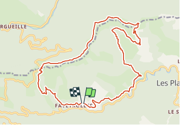

Length
12.9 km

Max alt
909 m

Uphill gradient
572 m
Km-Effort
20 km

Min alt
452 m

Downhill gradient
563 m
Boucle
Yes
Creation date :
2014-12-10 00:00:00.0
Updated on :
2014-12-10 00:00:00.0
4h44
Difficulty : Unknown

FREE GPS app for hiking
 SityTrail
IGN / Geographical institutes
SityTrail Plus
The world is yours!
About
Trail Walking of 12.9 km to be discovered at Occitania, Gard, Les Plantiers. This trail is proposed by grageot.
Description
belle randonnée Cévennes
Positioning
Country:
France
Region :
Occitania
Department/Province :
Gard
Municipality :
Les Plantiers
Location:
Unknown
Start:(Dec)
Start:(UTM)
555231 ; 4884302 (31T) N.
Comments